| change note
| - 2018-11-05 07:48:54.0 [mmorahan]
update Definition (PREFERRED TERMS: 3A, S3B, S3C, S3D, Sentinel-3
DEFINITION
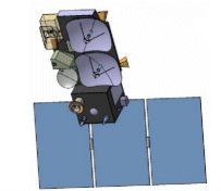
The Sentinel-3 (S3) mission of ESA and the EC is one of the elements of the GMES (Global Monitoring for Environment and Security) program, which responds to the requirements for operational and near-real-time monitoring of ocean, land and ice surfaces over a period of 20 years. The topography element of this mission will serve primarily the marine operational users but will also allow the monitoring of sea ice and land ice, as well as inland water surfaces, using novel observation techniques.The Sentinel-3 mission is designed as a constellation of two identical polar orbiting satellites, separated by 180º, for the provision of long-term operational marine and land monitoring services. The operational character of this mission implies a high level of availability of the data products and fast delivery time, which have been important design drivers for the mission.
BROADER CONCEPT: Earth Observation Satellite
ENTRY TERMS: SENTINEL-3
NOTE: A,B,C,D
HOSTS: DORIS, GNSS, MWR, OLCI, SLSTR, SRAL
URI: https://earth.esa.int/concept/sentinel-3);
- 2018-02-27 16:57:36.0 [sritz]
update Resource (image);
insert WeightedRelation (id: null
related concept uuid: 65ed042c-df53-4afb-8b6a-1ea16958015d
relationship type: null
relationship value: null
generated by: null);
- 2018-02-27 17:01:28.0 [sritz]
insert Resource (id: null
type: provider
url: https://earth.esa.int/web/guest/missions/esa-eo-missions/sentinel-3);
- 2019-03-26 16:18:45.0 [sritz] Insert Concept
add narrower relation (SENTINEL-3 [8a19f309-46ee-424b-be9f-e7e57e5b8ca0,345357] - SENTINEL-3B [41163801-6aac-43e5-aed7-9f52613a6a73,368597]);
- 2018-11-05 07:50:49.0 [mmorahan] Insert Concept
add narrower relation (SENTINEL-3 [8a19f309-46ee-424b-be9f-e7e57e5b8ca0,345357] - Sentinel 3A [5449d87b-5573-450f-8acb-2fdfeab3c8ce,368235]);
- 2018-11-05 07:31:54.0 [mmorahan] Cut Concepts
delete broader relation (null);
add broader relation (SENTINEL-3 [8a19f309-46ee-424b-be9f-e7e57e5b8ca0,345357] - Trash Can/Platforms [6089b3e5-7db9-46e1-b73b-2d679f34abb4,354203]);
- 2018-02-27 17:00:35.0 [sritz]
update Definition (entinel-3 is primarily an ocean mission, however, the mission is also able to provide atmospheric and land applications. The mission provides data continuity for the ERS, Envisat and SPOT satellites.
Sentinel-3 makes use of multiple sensing instruments to accomplish its objectives; SLSTR (Sea and Land Surface Temperature Radiometer), OLCI (Ocean and Land Colour Instrument), SRAL (SAR Altimeter), DORIS, and MWR (Microwave Radiometer).
Group: Platform_Details
Entry_ID: SENTINEL-3
Group: Platform_Identification
Platform_Category: Earth Observation Satellites
Platform_Series_or_Entity: Sentinel GMES
Short_Name: SENTINEL-3
End_Group
Group: Orbit
Orbit_Altitude: 800 km
Orbit_Type: LEO > Low Earth Orbit > Polar Sun-Synchronous
End_Group
Creation_Date: 2009-12-18
Online_Resource: https://earth.esa.int/web/guest/missions/esa-eo-missions/sentinel-3
Sample_Image: http://www.esa.int/images/sentinel_M.gif
Group: Platform_Logistics
Launch_Site: Kourou, French Guiana
Design_Life: 7 years
Primary_Sponsor: ESA/EU
End_Group
End_Group);
update Definition (https://earth.esa.int/web/guest/missions/esa-eo-missions/sentinel-3);
- 2018-06-12 15:20:10.0 [mmorahan] Move Concepts
delete broader relation (null);
add broader relation (SENTINEL-3 [8a19f309-46ee-424b-be9f-e7e57e5b8ca0,345357] - Earth Observation Satellites [3466eed1-2fbb-49bf-ab0b-dc08731d502b,344761]);
- 2018-06-12 15:26:14.0 [mmorahan] Move Concepts
delete broader relation (null);
add broader relation (SENTINEL-3 [8a19f309-46ee-424b-be9f-e7e57e5b8ca0,345357] - Sentinel GMES [2c9f1fcc-d9c8-4c6d-b701-45c97cee511f,344719]);
- 2018-11-05 07:32:05.0 [mmorahan] Move Concepts
delete broader relation (null);
add broader relation (SENTINEL-3 [8a19f309-46ee-424b-be9f-e7e57e5b8ca0,345357] - Earth Observation Satellites [3466eed1-2fbb-49bf-ab0b-dc08731d502b,344761]);
- 2018-02-27 16:58:04.0 [sritz]
update Definition (The ESA Sentinels will be the first series of noperational satellites to meet the Earth lobservation needs of the European Union ESA Global Monitoring for Environment and Security (GMES) programme. The pair of Sentinel-3 satellites will provide global, frequent and near-realtime ocean, ice and land monitoring. It continues Envisat’s altimetry, the multispectral, medium-resolution visible and infrared ocean and land-surface observations of ERS, Envisat and Spot, and includes enhancements to meet the operational revisit requirements and to facilitate new products and evolution of services. The first launch is expected in 2011/2012.
Summary Sourc : http://www.esa.int/esapub/bulletin/bulletin131/bul131c_aguirre.pdf
Grou : Platform_Details
Entry_ID: SENTINEL-3
Group: Platform_Identification
Platform_Category: Earth Observation Satellites
Platform_Series_or_Entity: Sentinel GMES
Short_Name: SENTINEL-3
End_Group
Group: Orbit
Orbit_Altitude: 800 km
Orbit_Type: LEO > Low Earth Orbit > Polar Sun-Synchronous
End_Group
Creation_Date: 2009-12-18
Online_Resourc : http://www.esa.int/esaLP/SEMZHM0DU8E_LPgmes_0.htm
Online_Resourc : http://www.esa.int/esaEO/SEMXK570A2G_environment_0.htm
Online_Resourc : http://en.wikipedia.org/wiki/Sentinel_
Online_Resourc : http://ec.europa.eu/gmes/index_en.ht
Sample_Imag : http://www.esa.int/images/sentinel_M.gi
Group: Platform_Logistics
Launch_Site: Kourou, French Guiana
Design_Life: 7 years
Primary_Sponsor: ESA/EU
End_Group
End_Group);
|
| definition
| - PREFERRED TERMS: 3A, S3B, S3C, S3D, Sentinel-3
DEFINITION
The Sentinel-3 (S3) mission of ESA and the EC is one of the elements of the GMES (Global Monitoring for Environment and Security) program, which responds to the requirements for operational and near-real-time monitoring of ocean, land and ice surfaces over a period of 20 years. The topography element of this mission will serve primarily the marine operational users but will also allow the monitoring of sea ice and land ice, as well as inland water surfaces, using novel observation techniques.The Sentinel-3 mission is designed as a constellation of two identical polar orbiting satellites, separated by 180º, for the provision of long-term operational marine and land monitoring services. The operational character of this mission implies a high level of availability of the data products and fast delivery time, which have been important design drivers for the mission.
BROADER CONCEPT: Earth Observation Satellite
ENTRY TERMS: SENTINEL-3
NOTE: A,B,C,D
HOSTS: DORIS, GNSS, MWR, OLCI, SLSTR, SRAL
URI: https://earth.esa.int/concept/sentinel-3 (en)
|


![[RDF Data]](/fct/images/sw-rdf-blue.png)

![[cxml]](/fct/images/cxml_doc.png)
![[csv]](/fct/images/csv_doc.png)
![[text]](/fct/images/ntriples_doc.png)
![[turtle]](/fct/images/n3turtle_doc.png)
![[ld+json]](/fct/images/jsonld_doc.png)
![[rdf+json]](/fct/images/json_doc.png)
![[rdf+xml]](/fct/images/xml_doc.png)
![[atom+xml]](/fct/images/atom_doc.png)
![[html]](/fct/images/html_doc.png)