| definition
| - The Global Position System (GPS), counterpart to the Russian Global Navigation
System (GLONASS), is a United States Department of Defense (DoD) developed,
worldwide, satellite-based radionavigation system that will be the DoD's
primary radionavigation system well into the next century. The constellation
consists of 24 operational satellites. The U.S. Air Force Space Command (AFSC)
formally declared the GPS satellite constellation as having met the requirement
for Full Operational Capability (FOC) as of April 27, 1995. Requirements
include 24 operational satellites functioning in their assigned orbits and
successful testing completed for operational military functionality.
GPS consists of three segments, the SPACE, CONTROL and USER Segment:
1. The SPACE segment consists of 24 operational satellites in six orbital
planes, (four satellites in each plane). The satellites operate in circular
20,200 km orbits at an inclination angle of 55 degrees and with a 12-hour
period. The position is therefore the same at the same sidereal time each day,
i.e. the satellites appear four minutes earlier each day.
2. The CONTROL segment consists of five Monitor Stations, three Ground
Antennas, and a Master Control Station (MCS) located at Falcon AFB in Colorado.
The monitor stations passively track all satellites in view, accumulating
ranging data. This information is processed at the MCS to determine satellite
orbits and to update each satellite's navigation message. Updated information
is transmitted to each satellite via the Ground Antennas.
3. The USER segment consists of antennas and receiver-processors that
provide positioning, velocity and precise timing to the user.
GPS provides two levels of service, Standard Positioning Service and the
Precise Positioning Service. The Standard Positioning Service (SPS) is a
positioning and timing service which will be available to all GPS users on a
continuous, worldwide basis with no direct charge. The Precise Positioning
Service (PPS) is a highly accurate military positioning, velocity and timing
service which will be available on a continuous, worldwide basis to users
authorized by the U.S.
[Summary provided by NASA.]
Group: Platform_Details
Entry_ID: GPS-36
Group: Platform_Identification
Platform_Category: Navigation Platforms
Platform_Series_or_Entity: GPS (Global Positioning System)
Short_Name: GPS-36
Long_Name: Global Positioning System Satellites-36
End_Group
Group: Platform_Associated_Instruments
Short_Name: GPS
Short_Name: GPS RECEIVERS
End_Group
Group: Orbit
Orbit_Altitude: 20,200 km
Orbit_Inclination: 64.8 degrees
Period: 718 minutes
Perigee: 20,030 km
Orbit_Type: MEO > Semi-Synchronous > Navigation
End_Group
Creation_Date: 2007-02-12
Online_Resource: http://ilrs.gsfc.nasa.gov/cgi-bin/satellite_missions/select.cgi?order=by_name&sat_code=GP36&sat_name=GPS-36&sat_no=9401601&tab_id=general
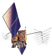
Sample_Image: http://ilrs.gsfc.nasa.gov/images/gps.gif
Group: Platform_Logistics
Launch_Date: 1994-04-10
Primary_Sponsor: U.S. Department of Defense
End_Group
End_Group (en)
|


![[RDF Data]](/fct/images/sw-rdf-blue.png)

![[cxml]](/fct/images/cxml_doc.png)
![[csv]](/fct/images/csv_doc.png)
![[text]](/fct/images/ntriples_doc.png)
![[turtle]](/fct/images/n3turtle_doc.png)
![[ld+json]](/fct/images/jsonld_doc.png)
![[rdf+json]](/fct/images/json_doc.png)
![[rdf+xml]](/fct/images/xml_doc.png)
![[atom+xml]](/fct/images/atom_doc.png)
![[html]](/fct/images/html_doc.png)