| definition
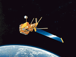
| - ADEOS (ADvanced Earth Observation Satellite), developed by the Japanese space agency JAXA. It was the largest satellite Japan has ever developed, having dimensions of 4 x 4 x 5 m. When antenna and the solar array paddle (approx. 3 x 24 m) were deployed, it had a span of 11m in the flight direction and 29 m in the perpendicular direction.It had a launch mass of approximatly 3500 kg and an in-orbit power generation capability of approximatly 4500W.
The spacecraft consisted of a mission module and a bus module.The bus module was made of thermally, electrically and mechanically independent units, including the Communications and Data Handling Subsystem, the Electrical Power Subsystem (EPS), the Attitude and Orbital Control Subsystem (AOCS) and the reaction Control Subsystem (RCS) for orbital maneuvers.
The mission module carried 8 instruments : Two core sensor developped by JAXA : AVNIR (Advanced Visible and Near Infrared Radiometer) and OCTS (Ocean Color and Temperature Temperature Sensor).Six Annoncement of Opportunity (AO) sensors : NSACT (NASA SCATterometer), TOMS (Total Ozone Mapping Spectometer), POLDER (POlarization and Directionality of the Earth'Reflectance), IMG (Interferometric Monitor for Greenhouse Gases), ILAS (Improved Limb Atmospheric Spectrometer), RIS (Retroreflector In Space).ADEOS-1 has been launched in August 1996 by H-II launcher from Tanegashima Space Center. Ninety seconds after liftoff, the solid rocket boosters separated from the H-II vehicle and 6 minutes after liftoff, the first stage separated. Then 16 minutes after liftoff, ADEOS-1 separated from the second stage. ADEOS-1 was lost on June 1997, the 30th, due to a solar panel cable breaking.[http://smsc.cnes.fr/POLDER/index.htm]
Group: Platform_Details
Entry_ID: ADEOS-I
Group: Platform_Identification
Platform_Category: Earth Observation Satellites
Platform_Series_or_Entity: ADEOS (Advanced Earth Observing Satellite)
Short_Name: ADEOS-I
Long_Name: Advanced Earth Observing Satellite-I
End_Group
Group: Platform_Associated_Instruments
Short_Name: POLDER-1
Short_Name: TOMS
Short_Name: RIS
Short_Name: OCTS
Short_Name: NSCAT
Short_Name: IMG
Short_Name: ILAS
Short_Name: AVNIR
End_Group
Group: Orbit
Orbit_Inclination: 98.6 degrees
Period: 101 minutes
Perigee: 797 km
Orbit_Type: LEO > Low Earth Orbit > Polar Sun-Synchronous
End_Group
Creation_Date: 2007-08-22
Online_Resource: http://ilrs.gsfc.nasa.gov/satellite_missions/list_of_satellites/ade1_general.html#instrument
Sample_Image: http://ilrs.gsfc.nasa.gov/images/adeos1.gif
Group: Platform_Logistics
Launch_Date: 1996-08-17
Design_Life: 3 years
Primary_Sponsor: Japan Aerospace Exploration Agency
End_Group
End_Group (en)
|


![[RDF Data]](/fct/images/sw-rdf-blue.png)

![[cxml]](/fct/images/cxml_doc.png)
![[csv]](/fct/images/csv_doc.png)
![[text]](/fct/images/ntriples_doc.png)
![[turtle]](/fct/images/n3turtle_doc.png)
![[ld+json]](/fct/images/jsonld_doc.png)
![[rdf+json]](/fct/images/json_doc.png)
![[rdf+xml]](/fct/images/xml_doc.png)
![[atom+xml]](/fct/images/atom_doc.png)
![[html]](/fct/images/html_doc.png)