| definition
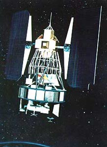
| - Landsat 1, originally named Earth Resources Technology Satellite 1, was a
modified version of the Nimbus 4 meteorological satellite. It was launched on
July 23, 1972, the first satellite of the United States' Landsat program. The
near-polar orbiting spacecraft served as a stabilized, Earth-oriented platform
for obtaining information on agricultural and forestry resources, geology and
mineral resources, hydrology and water resources, geography, cartography,
environmental pollution, oceanography and marine resources, and meteorological
phenomena.
To accomplish these objectives, the spacecraft was equipped with (1) a
three-camera return beam vidicon (RBV) to obtain visible light and near
infrared photographic images of Earth, (2) a four-channel multispectral scanner
(MSS) to obtain radiometric images of Earth, and (3) a data collection system
(DCS) to collect information from remote, individually equipped ground stations
and to relay the data to central acquisition stations. Landsat 1 carried two
wide-band video tape recorders (WBVTR) capable of storing up to 30 min of
scanner or camera data to give the spacecraft's sensors a near-global coverage
capability.
An advanced attitude control system consisting of horizon scanners, sun
sensors, and a command antenna combined with a freon gas propulsion system
permitted the spacecraft's orientation to be maintained within plus or minus
0.7 degrees in all three axes. Spacecraft communications included a command
subsystem operating at 154.2 and 2106.4 MHz and a PCM narrow-band telemetry
subsystem, operating at 2287.5 and 137.86 MHz, for spacecraft housekeeping,
attitude, and sensor performance data. Video data from the three-camera RBV
system was transmitted in both real-time and tape recorder modes at 2265.5 MHz,
while information from the MSS was constrained to a 20 MHz rf bandwidth at
2229.5 MHz.
In 1976, Landsat 1 discovered a tiny uninhabited island 20 km off the eastern
coast of Canada. This island was thereafter designated Landsat Island after the
satellite. As of 2006, it is the only island to be discovered via satellite
imagery.
The spacecraft was turned off on January 6, 1978, when cumulative precession of
the orbital plane caused the spacecraft to see almost constant sunlight which
led to overheating.
[Summary provided by NASA.]
Group: Platform_Details
Entry_ID: LANDSAT-1
Group: Platform_Identification
Platform_Category: Earth Observation Satellites
Platform_Series_or_Entity: LANDSAT
Short_Name: LANDSAT-1
End_Group
Group: Platform_Associated_Instruments
Short_Name: MSS
Short_Name: RBV
End_Group
Group: Orbit
Orbit_Altitude: 917 km (570 mi)
Orbit_Inclination: 99.2 degree
Equator_Crossing: 9:30 AM +/- 15 minutes
Period: 103 minutes
Repeat_Cycle: 18 days
Orbit_Type: LEO > Low Earth Orbit > Polar Sun-Synchronous
End_Group
Creation_Date: 2007-02-01
Online_Resource: http://landsat.gsfc.nasa.gov/about/L1_td.html
Sample_Image: http://space.skyrocket.de/img_sat/landsat-1.jpg
Group: Platform_Logistics
Launch_Date: 1972-07-23
Launch_Site: Vandenberg AFB
Primary_Sponsor: NASA
Primary_Sponsor: USGS
End_Group
End_Group (en)
|


![[RDF Data]](/fct/images/sw-rdf-blue.png)

![[cxml]](/fct/images/cxml_doc.png)
![[csv]](/fct/images/csv_doc.png)
![[text]](/fct/images/ntriples_doc.png)
![[turtle]](/fct/images/n3turtle_doc.png)
![[ld+json]](/fct/images/jsonld_doc.png)
![[rdf+json]](/fct/images/json_doc.png)
![[rdf+xml]](/fct/images/xml_doc.png)
![[atom+xml]](/fct/images/atom_doc.png)
![[html]](/fct/images/html_doc.png)